EMBARGOED UNTIL 00:01 on Monday 24.07.2023
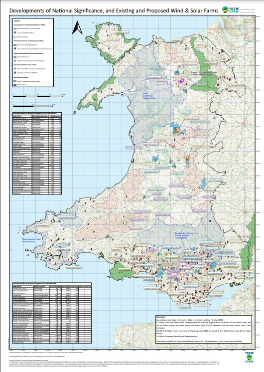
CPRW reveals map showing all present applications being proposed across Wales through the Developments of National Significance planning system

CPRW recently has asked PEDW, the body overseeing all application under the Developments of National Significance (DNS) process, for geospatial data, or to produce a map of all the current applications.
Spokesperson for CPRW, Ross Evans, says as PEDW have been unable create a map themselves, CPRW members have produced one to show all the current proposals for onshore wind and ground-based solar.
“In the absence of an official map to show the scale of applications facing the Welsh countryside, our members have painstakingly plotted and annotated a map showing all the DNS applications, what this map illustrates can only be called the industrialisation of our countryside.
“One thing noticeable from our map is the fallacy of the Welsh Government’s Pre-Assessed Areas. Most applications are outside of these areas and, at least one foreign developer, has withdrawn a major application within one of these areas claiming it wasn’t suitable*.
“We are supposed to be in a nature emergency, as well as a climate emergency. Yet the Welsh Government seem happy to ride roughshod over nature in it’s “race to net zero”.
“We are proud to unveil this map at our stall at the Royal Welsh Agricultural Show, if you are attending this year come and see for yourself at stall CCA84, if not you can download a copy from our website.” said Evans.
CPRW have long taken issue with the DNS system saying it has a deficit of democracy, they recently said the application process was not fit for purpose, given a recent admission from PEDW that they could not cope with the scale of applications before them.
The CPRW stall (find with What3Words with: fashion.cringes.breed ) at the Royal Welsh Agricultural Show 2023 is directly behind the Welsh Government building in the Countryside Care section, pop along to see the map, have a cuppa and a friendly chat about what CPRW are fighting to save.
A copy of the map unveiled at the show can be downloaded here: https://cprw.org.uk/wp-content/uploads/2023/07/Developments-of-National-Significance-RWAS-V1.7a-20230711.pdf
Or a more detailed version showing common land and flight routes for the RAF at the Mach Loop can be downloaded here: https://cprw.org.uk/wp-content/uploads/2023/07/Developments-of-National-Significance-CPRW-V1.7a-20230711.pdf
[instagram-feed feed=1]


